Part 2 - Jefferson County: "Stuck by Design"

Part 2 – The Map Inside the Market
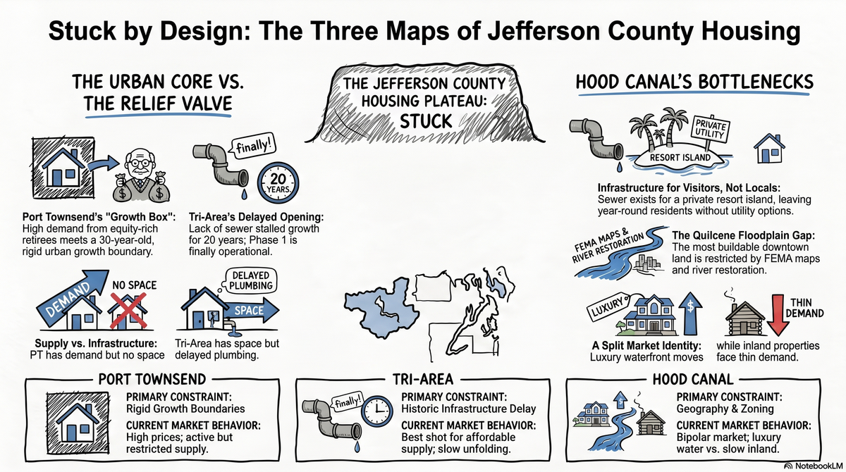
How Port Townsend, the Tri‑Area, and Hood Canal each get stuck in their own way
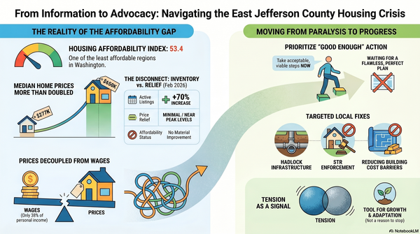
If you only look at county‑wide numbers, Jefferson County just looks confused. Inventory is up sharply over the past year, but median prices are still hovering near their 2022 peak. It’s not a crash. It’s a plateau. This is a market that is stuck, not by accident, but by design.
To understand what that actually feels like on the ground, you have to zoom in. At street level, we don’t have “one” market at all. We have three very different maps—Port Townsend, the Tri‑Area, and the Hood Canal corridor—that all lead to the same stuck place by different routes.
1. Port Townsend: the strong market inside a tight container
Let’s start where the story is most familiar: in‑town Port Townsend.
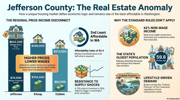
On the surface, Port Townsend is still the strongest part of the county. In‑town medians sit in the low‑ to mid‑$600,000s, with high price‑per‑square‑foot numbers. Well‑priced, move‑in‑ready homes downtown can still go pending in two to three months, even as the rest of the county slows.
That doesn’t look stuck at first glance. But look at the container we’ve built around it.
Port Townsend is our main amenity center: hospital, schools, historic core, arts, restaurants, walkability—all in one compact footprint. The dominant buyer is not the median local household; it’s equity‑rich retirees and remote workers whose budgets don’t rise and fall with mortgage rates the way a working family’s does. At the same time, the city’s urban growth boundary has barely budged in 30 years, and the first serious attempt at adding meaningful density is already tied up in an appeal that’s soaking up staff time instead of turning on new housing tools.
So yes, homes in Port Townsend still sell. But they sell inside a growth box that barely expands. The lack of new supply, plus the nature of the buyer pool, is exactly why prices stayed stubborn even as rates doubled and sales volume fell. That is “stuck by design” in its purest form: a strong amenity town that can’t grow easily, serving buyers who can pay more than the local workforce ever could. The market inside PT is active; the system around it is rigid.
2. The Tri‑Area: the relief valve that never really opened
Now slide down the map to Port Hadlock, Irondale, and Chimacum.
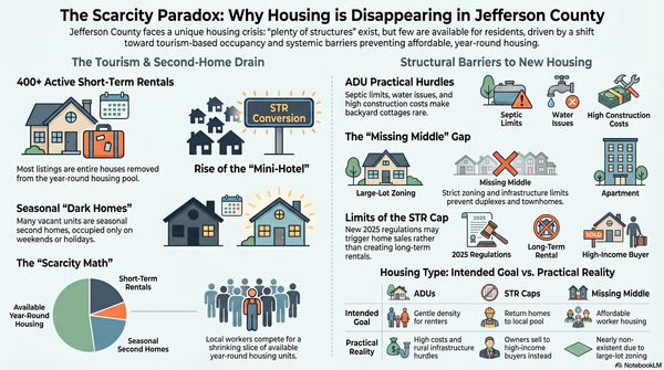
On paper, the Tri‑Area is supposed to be the relief valve. The Irondale/Port Hadlock Urban Growth Area was created so we’d have a place, outside Port Townsend, where urban‑level densities and infrastructure could absorb growth. Zoning here often allows city‑style density on the books.
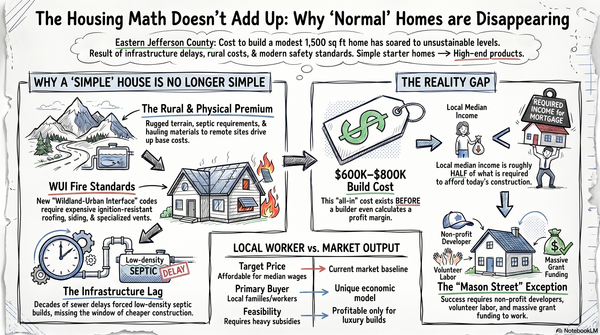
In reality, the Tri‑Area spent the last two decades stuck at something closer to rural densities, because the critical ingredient—sewer—simply never showed up. Septic rules effectively capped how much we could build, no matter what the zoning map said.
That finally changed: Phase I of the Port Hadlock sewer is now built and operational. It focuses on the commercial core today, but unlike the private sewer system proposed for Pleasant Harbor, Hadlock’s is public infrastructure. Over time, it can be extended into surrounding neighborhoods and used as the backbone for real, year‑round housing.
That’s why the Tri‑Area looks the way it does right now. Prices typically run a solid notch below in‑town Port Townsend. It’s close enough to share amenities and jobs, but it never got the full town center and housing production the UGA was designed for.
The design problem here is time. We drew the right map 20 years ago and then failed to build the plumbing until after the affordability crisis exploded. That’s how you end up with a “designated growth area” where the growth never quite arrives.
For buyers, the Tri‑Area is now the most realistic place to get a relatively affordable home within striking distance of Port Townsend. For the system as a whole, it’s the place where we will either finally unstick the map—or replay the same pattern of delay around Phase II sewer and actual housing permits.
3. Hood Canal (Quilcene & Brinnon): two markets and three bottlenecks
Drive further south and the story changes again.
Brinnon and Pleasant Harbor: sewer, but only for a resort
Just south of Brinnon lies Pleasant Harbor, the county’s long‑running Master Planned Resort project. On paper, Pleasant Harbor is a big deal: hundreds of acres mapped for an urban‑intensity resort, with condo/hotel units, marina facilities, and amenities, all carved out as a special exception to rural zoning.
To make that possible, the project includes its own dedicated water and sewer systems—a self‑contained utility island designed so the county doesn’t have to run public sewer down Hood Canal. The local PUD has even agreed to operate those systems if the developer can’t, which shows how far the technical planning has gone despite the on‑again, off‑again timing of the resort itself.
This creates a strange picture: the one place in south county with a real sewer plan is a private resort footprint, not the existing Brinnon community. The master plan also locks a large, strategic chunk of land into resort use rather than workforce housing, potentially for decades.
From a “stuck by design” standpoint, Pleasant Harbor is a perfect example of how we solved infrastructure for a hypothetical visitor, but not for the people who actually live and work there. Even if it’s fully built, it does very little to fix Brinnon’s lack of everyday, year‑round housing stock.
Quilcene: the town center that lives in the floodplain
Quilcene’s constraint is different, but it rhymes.
If you stand in town and look toward the bay, the obvious place for a walkable little village core and additional housing is the flat land along the lower Big Quilcene River and estuary. That’s also exactly where the river wants to go during big storm events.
Over the last decade, the county and partners have bought and cleared repeatedly flooded properties in that lower river corridor, turning large areas into open space and restoration ground. FEMA maps and local floodplain rules now heavily restrict new development in these areas or require costly elevation and mitigation to build.
Practically, that means the flattest, most connected land near “downtown” Quilcene is largely off the table for new housing. The remaining buildable land is up the hill, fragmented, or locked into rural/forestry zoning that doesn’t allow meaningful village‑scale density.
So you get a familiar pattern in a different costume: a small town that can’t really grow where it naturally wants to, plus a zoning map that doesn’t clearly provide a Plan B on safer ground. The hammer‑shaped gap in Quilcene’s map is the floodplain itself.
Market behavior on Hood Canal
Layer those design choices over the actual market and you see why Hood Canal behaves the way it does.
Inland Quilcene and Brinnon offer relatively lower‑priced homes, but with very thin demand and long days on market. On the water, you have a luxury and second‑home market with a huge premium over inland pricing, driven by outside capital and lifestyle preferences rather than local incomes.
Different constraints—resort zoning, private sewer, floodplain, rural density—same end result: it’s almost impossible to build the modest, year‑round housing that would make these communities function as healthy villages with a range of working households.
4. Why this map matters
If you’re a buyer or a seller, this isn’t just inside baseball. It shapes your real options.
In‑town Port Townsend is where you still see the most consistent demand and the quickest sales, but you pay for the privilege and you’re buying into a town priced by retirees and remote workers, not by local wages. The Tri‑Area is the county’s best shot at adding actual supply now that sewer is finally in the ground—but the benefits will unfold over years, not months. Hood Canal is split: slow, negotiable inland properties on one side; extremely scarce, lifestyle‑priced waterfront on the other, with big structural limits on adding anything in between.
The through‑line is the same: Jefferson County’s housing problems are not going to self‑correct just because interest rates move or a few more listings hit the MLS. The map itself—the way we’ve drawn boundaries, delayed infrastructure, and chosen where we will and won’t allow real village‑level growth—is what keeps this market stuck by design.
In Part 3, we’ll talk about what that means if you’re trying to buy or sell in the next 12–24 months, and how to play the hand you’ve been dealt in each of these very different sub‑markets.